File:LocationTurkey.png
No higher resolution available.
LocationTurkey.png (250 × 115 pixels, file size: 7 KB, MIME type: image/png)
Summary
| Description |
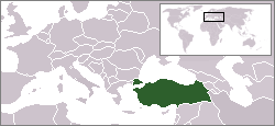
English: Location map for the Turkey
Türkçe: Türkiye'nin yerini gösteren harita
Deutsch: Karte zur Lage der Türkei. |
| Date | |
| Source | Originally created for English Wikipedia by Vardion. |
| Author | Vardion |

|
File:LocationTurkey.svg is a vector version of this file. It should be used in place of this PNG file.
File:LocationTurkey.png → File:LocationTurkey.svg
For more information, see Help:SVG. |
 |
Licensing
| This work has been released into the public domain by its author, Vardion at English Wikipediya. This applies worldwide. In some countries this may not be legally possible; if so: Vardion grants anyone the right to use this work for any purpose, without any conditions, unless such conditions are required by law. |
File history
Click on a date/time to view the file as it appeared at that time.
| Date/Time | Thumbnail | Dimensions | User | Comment | |
|---|---|---|---|---|---|
| current | 00:32, 11 January 2007 | | 250 × 115 (7 KB) | AtilimGunesBaydin | Modified layout. |
| 10:43, 9 June 2006 |  | 250 × 115 (7 KB) | Aivazovsky~commonswiki | ||
| 15:59, 6 June 2006 |  | 250 × 115 (7 KB) | Rain74 | Serbia & Montenegro | |
| 19:52, 20 May 2005 |  | 250 × 115 (7 KB) | Thuresson | Återgått till yngre version | |
| 19:02, 20 May 2005 |  | 135 × 155 (12 KB) | Dionis~commonswiki | ||
| 12:49, 20 May 2005 |  | 250 × 115 (7 KB) | CengizS~commonswiki | Reverted to earlier revision | |
| 05:06, 20 May 2005 |  | 135 × 155 (12 KB) | Dionis~commonswiki | ||
| 15:20, 9 December 2004 |  | 250 × 115 (7 KB) | EugeneZelenko | Location map for the Turkey.<br/>Originally created for English Wikipedia by Vardion.<br/>{{PD}}<br/>Category:Country locator maps |
File usage
There are no pages that use this file.