File:Huairivermap.jpg
No higher resolution available.
Huairivermap.jpg (721 × 462 pixels, file size: 220 KB, MIME type: image/jpeg)
Summary
| Description |
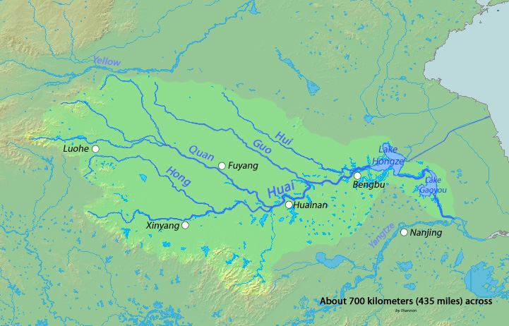
English: Map of the Huai River, whose watershed drains much of eastern China between the Yellow River (Huang He) and Chang Jiang (Yangtze River), eventually flowing into the Yangtze—Chang Jiang. |
| Date | |
| Source | Background and river course data from http://www2.demis.nl/mapserver/mapper.asp |
| Author | Shannon |
Licensing
I, the copyright holder of this work, hereby publish it under the following licenses:

|
Permission is granted to copy, distribute and/or modify this document under the terms of the GNU Free Documentation License, Version 1.2 or any later version published by the Free Software Foundation; with no Invariant Sections, no Front-Cover Texts, and no Back-Cover Texts. A copy of the license is included in the section entitled GNU Free Documentation License. |
This file is licensed under the Creative Commons Attribution-Share Alike 4.0 International, 3.0 Unported, 2.5 Generic, 2.0 Generic and 1.0 Generic license.
- You are free:
- to share – to copy, distribute and transmit the work
- to remix – to adapt the work
- Under the following conditions:
- attribution – You must give appropriate credit, provide a link to the license, and indicate if changes were made. You may do so in any reasonable manner, but not in any way that suggests the licensor endorses you or your use.
- share alike – If you remix, transform, or build upon the material, you must distribute your contributions under the same or compatible license as the original.
You may select the license of your choice.
File history
Click on a date/time to view the file as it appeared at that time.
| Date/Time | Thumbnail | Dimensions | User | Comment | |
|---|---|---|---|---|---|
| current | 03:16, 3 March 2010 | | 721 × 462 (220 KB) | Shannon1 | {{Information |Description={{en|1=Map of the Huai River, whose watershed drains much of eastern China between the Yellow and Yangtze Rivers, eventually flowing into the Yangtze}} |Source=Background and river course data from http://www2.demis.nl/mapserver |
File usage
There are no pages that use this file.