File:Lusophone World.svg

Size of this PNG preview of this SVG file: 800 × 353 pixels. Other resolutions: 320 × 141 pixels | 640 × 283 pixels | 1,024 × 452 pixels | 1,280 × 565 pixels | 2,560 × 1,130 pixels | 940 × 415 pixels.
Original file (SVG file, nominally 940 × 415 pixels, file size: 1.49 MB)
Summary
| Description |
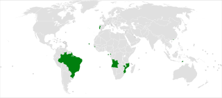
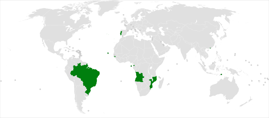
Deutsch: Diese Karte zeigt die Länder der portugiesischsprachigen Welt: Angola, Äquatorialguinea, Brasilien, Guinea-Bissau, Kap Verde, Macao, Mosambik, Osttimor, Portugal, São Tomé und Príncipe. English: This map is showing the countries of the Lusophone world: Angola, Brazil, Cape Verde, East Timor, Equatorial Guinea, Guinea-Bissau, Macau, Mozambique, Portugal, São Tomé and Príncipe. |
| Date | |
| Source | Own work |
| Author | Saftorangen |
| Permission (Reusing this file) |
I, the copyright holder of this work, hereby publish it under the following license: This file is licensed under the Creative Commons Attribution-Share Alike 3.0 Unported license.
|
| Other versions |
Derivative works of this file: Lusophone World AR.png File:Map-Lusophone World-en.png |
| SVG genesis |
File history
Click on a date/time to view the file as it appeared at that time.
| Date/Time | Thumbnail | Dimensions | User | Comment | |
|---|---|---|---|---|---|
| current | 21:34, 20 August 2020 | | 940 × 415 (1.49 MB) | Hogweard | South Sudan border |
| 09:44, 26 May 2010 |  | 940 × 415 (1.45 MB) | Saftorangen | .mo -> .cn_mo ...finalfix, works | |
| 09:37, 26 May 2010 |  | 940 × 415 (1.45 MB) | Saftorangen | .mo displayfix | |
| 19:14, 25 May 2010 |  | 940 × 415 (1.45 MB) | Saftorangen | +.gq, -.cq | |
| 19:07, 25 May 2010 |  | 940 × 415 (1.45 MB) | Saftorangen | {{Information |Description={{en|1=This map is showing the Lusophone world.}} {{de|1=Diese Karte zeigt die lusophone Welt.}} |Source={{own}} |Author=Saftorangen |Date=2010-05-25 |Permission= |other_versions=[[:File:Map-Lusophone World- |
File usage
There are no pages that use this file.